Friday, June 28, 2019

Glacier National Park

Hello Everyone,

My human parents and I are staying in Whitefish, MT for the next two nights, while we explore the park. Today we drove about thirty minutes to the park, stopped at the Apgar visitors center to get oriented, then took a little hike to Apgar Village at the end of Lake McDonald. I met many new people that I could befriend, and on the way back we met six young couples that stopped to say "hi" and pet me. One of them had on a "Brockport" t-shirt and Mom asked them if they were from Brockport, NY? They said, No, they were from Greece, NY near Rochester. We told them we were from Honeoye Falls and they were all excited. One of the girls said, "How ironic, we are nearly 5,000 miles from home and we meet people from home here in Glacier".

As we drove past the end of Lake McDonald we stopped to see McDonald Falls. Then we started up the "Road to the Sun" where we passed through a tunnel blasted right through the side of the mountain.

The road is very steep and narrow, which made both Dad (who has an aversion to heights) and Mom very nervous. There were deadly drop-offs of more than 1,000 feet in many places and neither Dad nor Mom felt safe. As we went up, up, up we could see the glaciers at the top of the highest mountain peaks.

Yep, those are glaciers on those mountains in the distance. We could see them better as we got closer and higher up. Notice the Lodge Pole Pines in the foreground. They grow up to 80-90 ft high and only have branches near the top.

This is Heaven's Peak at 8,987 feet. Way up here the glaciers are much easier to see.

We haven't seen any bears yet, but there are warning signs and the park rangers recommend taking "bear spray" with you if you go out hiking. There are several warnings throughout the park instructing you what to do if you encounter a bear.
Tomorrow we plan to do some hiking. Wish us luck!😆

Thursday, June 27, 2019

The National Bison Range

Hi Everyone,

Well, we made it! We were trying to reach Glacier National Park by June 27th and we did it. The web site says the "Going to the Sun" road was finally opened on June 24th, where road crews removed up to thirty feet of snow accumulation from the previous winter. Wow, thirty feet, that's a lot of snow! Dad and Mom and I are staying in a nice house outside of the park for the next 3 days in Whitefish, MT.

On the way there we stopped at the National Bison Range preserve and drove through a one-way loop road that took us up and over some mountains that made Dad nervous because there were steep drop-offs and no guard rails on a very narrow dirt road. We saw several Bison, Elk, mule deer, white-tailed deer and lots of magpies (birds). Here is a pile of Elk antlers I saw at the visitor's center.


When we arrived at the top we were up so high we were above the clouds.

Mom took some great pictures of the wildlife we saw there, while I mostly watched from the car window. I only got out of the car a few times because there were signs saying there had been recent grizzly bear activity in the area.

Notice how the velvet on the Elk's antlers hasn't fallen off yet. That is because they just had 17 inches of snow less than three weeks ago out here.

The Bison hasn't completely shed his winter coat yet either. The people around here say there was no Spring this year. They went from Winter weather right into Summer weather.

The huge ears on the mule deer make it easy to identify, and there is no whitetail either, like on the white-tailed deer we have in the East.

Many of the prairie flowers are just starting to bloom, and it is almost July.

Tomorrow we start exploring Glacier National Park. I can't wait to see what new things we will see on our Great Adventure😄.

Wednesday, June 26, 2019

New Adventures in Montana

Hi Everyone,

Wednesday, June 26, was a relaxing day, we only traveled for about two hours, from Three Forks to Missoula, Montana. We stopped at another state park called Lost Creek State Park near Anaconda, Montana.

It was a great park in a slot canyon with very steep and high cliffs on both sides, very similar to Zion National Park, but not as big.


While Mom and Dad were searching the cliffs with their monoculars for Bighorn Sheep to take pictures of, I found the lost creek!

When a man came by in a white truck with markings on the side saying "State Park" I tried to tell him I found it, but he didn't listen. I guess he doesn't speak "cute puppy language" very well. There was a very nice waterfall too, aptly called Lost Creek Waterfall. Imagine that?

We are getting up early tomorrow to go to a wildlife preserve where we hope to see Bison, Bighorn Sheep, Elk, Swans, and Pelicans if we can get there early enough. See you then😇.

Tuesday, June 25, 2019

Crossing Montana

Hello Everyone,

The past two days, June 23rd 24th, we have driven about 300 miles each day stopping only a couple of times to visit one national battlefield and one state park. We spent last night in another My Place Hotel in Billings, MT, and liked just as much as the first one we tried in North Dakota. 

I have been sleeping in my home (crate) that we brought with us a few more times. It is nice to have something that I used in my old home in Honeoye Falls, NY so I don't feel so displaced. 

We drove an extra 60 miles South on June 24th so Dad could visit the Little Bighorn National Battlefield Memorial in the Crow Indian Reservation in South East Montana. Mom and I had to stay in the parking lot because again, cute puppies like me are not allowed to leave the parking lot. Dad was very nice about not keeping us in the hot sun too long while he toured the battlefield (Last Stand Hill) and attended a ranger talk about the battle which resulted in the deaths of Lt. Col. George Armstrong Custer and about 210 troopers of the US 7th cavalry along with seven Indian scouts and several civilians that traveled with Custer and his command (including his brother and brother in law).

Custer made the mistake of splitting his 600 man command, hoping to surprise and defeat the Indian warriors from a camp along the Little Bighorn River after receiving orders from his commanding general to forcibly bring in a band of Indians who had left the reservation in North Dakota. Unfortunately for him and the members of the 7th cavalry that accompanied him, he became cut off from the remainder of his troops and was forced to make a stand against overwhelming odds (210 US soldiers against 1,500 to 2,000 mostly Sioux and Cheyenne warriors armed with rifles, bows and arrows and war clubs). He didn't stand a chance of winning against such overwhelming odds.
What Custer didn't know was that warriors from six different Indian nations had banded together to fight "the white man's army".

The Indian tribes were eventually defeated after newspapers in the East got word of the massacre of Custer and his men, and Congress appropriated enough money to raise a huge army to be sent West and put down the plains Indian tribes once and for all. The final chapter of this shameful organized annihilation of these once proud people, was a massacre of more than 300 women, children and old people a Wounded Knee, South Dakota, effectively ending "The Great Sioux Indian War", as it was called.

Today, June 25th, we drove from Billings Montana to Bozeman,. On the way, we stopped at Big Timber to pick up some brochures and a map at a visitor's center along route US 90 (where the speed limit is 80 MPH). There we saw a statue of the famous painter Charles Russell, known for his authentic Western art.

In Bozeman, we had lunch at a Chipotle restaurant in the center of the city, where I met a Bobcat and tried to make friends with him. It didn't work, and then Mom told me it was a statue, so I guess that's why.


From there we drove to Three Forks, Montana, where we are staying tonight. Then went to the nearby Missouri Headwaters State Park, where the Jefferson, Madison, and Gallatin Rivers all converge to create the mighty Missouri River, which flows into the mighty Mississippi River, ending at the Gulf of Mexico. This was the terminus of the Lewis and Clark Expedition as far as water travel in 1805. From here they were forced to continue on foot over the high Rocky mountains lead by a young Indian woman named Sacajawea to the Columbia River and onto the Pacific coast.

Tomorrow we are heading to Missoula, Montana where we are going to visit a ghost town and a state park with waterfalls. See you there😌.

Sunday, June 23, 2019

3,864 miles from my old home !

Hi Everyone,

We have been on the road for two weeks today. The car says we have traveled 3,864 miles from Rochester, NY.  Dad says we have crossed eight states and now we are entering the ninth state, North Dakota. Yesterday, June 22nd, we drove over three hours to get to Dickinson, North Dakota. Dad wasn't feeling well (must have been something he ate), so Mom drove for the first time since we left home. We found a new hotel we had not heard of before called "My Place' and spent the night there.
Our room was very nice with a small kitchenette, a full-sized refrigerator, a nice bathroom, and a comfortable king-size bed. We liked this hotel so much we are going to look for more as we travel.

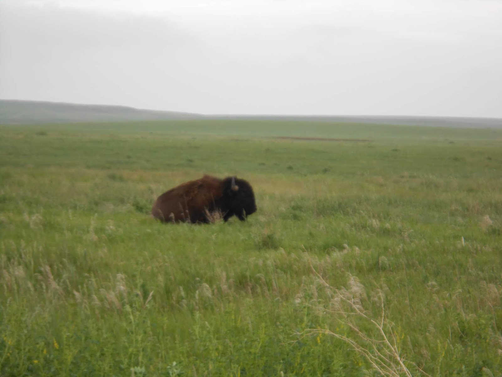
Today, June 23rd, we got up and drove 33 miles to the Painted Canyon Visitors Center in Theodore Roosevelt National Park, near Medoro, ND. The Painted Canyon looks very much like the Badlands of South Dakota. Unfortunately, we saw very little wildlife, only a few solitary Bison"bachelors" (male Bison who leave the herd after the calves are born, to go off on their own and roam the prairie).


The prairie dog towns were big and numerous. We enjoyed watching them cavorting around their holes, standing watch for predators, issuing a warning to their friends when someone got to close, and clowning around for the general enjoyment of the multitude of tourists, with license plates indicating people from many states besides North Dakota. The way these little critters send a warning is by standing straight up, throwing up their arms, similar to doing a cheer at a ball game, and issuing a shrill squeal. Florida appeared to be the furthest away. But New Jersey, New York (us), Texas, North Carolina, Illinois, Iowa, Montana, and South Dakota, were among the ones next to our car in the parking lot at the Visitor's Center.

At one of the overlooks, we saw some very pretty cactus that had just bloomed. Mom said I couldn't go over there because they're were spines sticking out from the cactus that might get into my eyes.

This national park is named after President Theodore Roosevelt who first came here at the age of 24 in 1883, to hunt Buffalo. He was successful and returned to his home on Long Island only to suffer a tragic loss. His wife and his mother both died within a short time and he became depressed. A year later he returned to North Dakota to grieve and lose himself in the vastness of the Badlands. He became a cattle rancher and in this broken land, he found adventure, purpose, and solace from his personal tragedy. In later years he credited his love of nature and personal strength of character to this period, which eventually translated into a successful run for the US presidency.
While in office he created the US Forest Service and signed into law the 1906 Antiquities Act, which he used to proclaim 18 national monuments, 150 national forests, and dozens of federal reserves-totaling 230 million acres of protected land. His ranch still exists inside the park where much care has been taken to restore it to its original state.


There are two parts to this national park, the North Unit, and the South Unit, nearly 60 miles apart, each has its own distinct characteristics. The northern unit follows the Little Missouri River valley for several miles, with rolling prairie which abounds in many forms of wildlife. The southern unit consists mostly of Badlands similar to those in South Dakota, with numerous hiking trails for the adventurous in both units. Mom and Dad and I met lots of new and interesting people at the Visitor's Center and each time we stopped at an overlook or to take pictures of wildlife.

Tomorrow we are going back to Theodore Roosevelt National Park to see some more parts of the park we didn't have time to see today. See you later 😉.

Friday, June 21, 2019

Goodbye South Dakota

Hello Everyone,

Today we got up, packed the car to move on, and drove back into Custer State Park once more to see the Needles Highway which had been closed for resurfacing the last two days. It was spectacular! Here are a few pictures of the narrow winding road that passed through very narrow tunnels, past spires that look like rock needles (how it got its name) that really don't do it justice.


Below is the eye of the needle rock formation.

Then we stopped at Sylvan Lake for a nice hike (2 miles) around a beautiful man-made lake.


After that, we drove another two hours West into Wyoming to see Devils Tower National Monument.


Wow, was it big! It stands 1280 feet high in the middle of the high plains a few miles over the border from South Dakota, in an otherwise mostly flat plain area.
 There are several Indian legends on the origin of this prominent feature. They say that "seven Indian girls were playing when a huge bear approached them.  The girls were terrified and they ran for their lives with the bear right behind them. They came to the stump of a great tree, the tree spoke to them, saying to climb upon it. As they did so, it began to rise and grow larger, bearing them higher than the bear could reach. The angry bear reared up against the tree and scored the bark with its claws, causing the marks that still remain to this day. The girls continued to rise into the sky and eventually became the stars of the Pleiades constellation".
 I don't know if it is true, but it was fun listening to the story. I met several dozen nice people who enjoyed petting me and talking to my human parents. Many people seem surprised that we have come all the way from Rochester, NY. 

Then we drove to Belle Fourche, SD where we will stay overnight and press on to North Dakota and Theodore Roosevelt National Park tomorrow😉. 


More Adventure in South Dakota

Hi Everyone,
Yesterday, June 18th we left Spearfish, SD, and drove through Spearfish Canyon where we saw breathtaking views of sheer canyon walls hundreds of feet high and awe-inspiring drop-offs on either side of the road. We took a short hike through the canyon on a trail marked “Devil’s Bathtub”, but we had to turn around when we reached a point where we had to cross a creek that was swollen from recent rains. We drove through a heavy rainstorm through Lead and Deadwood, South Dakota on our way to Custer, SD. When we arrived at Hill City we stopped at the Prairie Berry Winery, and Mom and Dad had a wine tasting while I got to meet and greet many new people. It was fun.


We arrived at Custer, SD in the afternoon, located our motel where we will be staying for three days and went to a local store to get some groceries. It was a great place to stay. The owner of the Chalet Motel, Michelle Lamphere, was a wonderful host and she liked me right away. Smart and good instincts too!
 Mom received a call from one of the places we had reserved near Glacier National Park saying that the owner was going to have to cancel our reservation because of some legal issues with another guest staying there, so she spent nearly all evening trying to get another place to stay when we get there next week. Dad shucked corn and cut up carrots for dinner while Mom contacted VRBO and the owner to get a refund of our money. 


The next morning, June 19th, we drove up the road a few miles to Custer State Park, a beautiful scenic area near Mt. Rushmore in the Black Hills of South Dakota. There we took a short, but nice hike around Legion Lake (1 mile). On the way to the lake, we saw two big bull Buffaloes walking in the road and stopping traffic. I tried to tell them to move, but they didn’t listen. 

Then we went to the visitors center where we took another hike up to the State Game Lodge and back to the parking lot (2 miles).

In the afternoon Dad and Mom drove 18 miles to Mt. Rushmore, while I stayed in our room and took a nap because cute puppies are not allowed to go there. Those fools! 

Once there they encountered a throng of visitors who came here to view the 60 ft sculptures of four of our greatest Presidents that are carved into the Granite cliff side. George Washington, Thomas Jefferson, Teddy Roosevelt, and Abraham Lincoln stare out across the Black Hills of South Dakota and remind us of what a great nation they helped to create.


On June 20th, we got up early so we could go back to Custer State Park and drive down the Wildlife loop road. There we saw Mule deer, Whitetail deer, Pronghorn Antelope, the begging Burros, many Bison with some recently born calves, and Bighorn Sheep. The Begging Burros are burros that used to be used for kids to ride on, but when they became unpopular the park administration released them into the wild where they soon learned that visitors would feed them from their car windows. So now they surround cars that travel through the valley and beg for food through an open window.


Then we took another hike on the Stockade Lake loop trail (3 miles). 

After lunch, we drove twenty miles to Wind Cave National Park. There we hiked up and around the crest of the hill above the parking lot for entrance to the cave. We decided not to go into the caves because again, cute puppies are not allowed. I don’t know what is wrong with these people? I met lots of people and did my best to make them feel good, but they still wouldn’t let me in. 


So we left Wind Cave and drove back to Custer, then on the Crazy Horse Memorial to take some more pictures to share with you all. Crazy Horse was a war chief that led his warriors in the successful defeat of George Armstrong Custer and his notorious 7th cavalry at the battle of the Little Bighorn River in Montana, where they all perished to the last man. The memorial is not finished yet, so you can only see his head carved into the granite cliff. When it is finished, it will be the largest sculpture in the world.

Tomorrow we are driving to Devil’s Tower National Monument in Wyoming. See you then😊.


Monday, June 17, 2019

Deadwood, SD (Wild Bill Hickok's last known address)

Hello Everyone,

Whew, we got up at 4:00 AM local time, so we could take some sunrise pictures out in the badlands. Mom was right, the colors are much more vivid in the early morning sunlight, especially the yellows and reds.

Here is a rare photo of Mom doing her thing at Badlands National Park.


Then we drove down a dirt road that bordered on the Indian reservation near the park, where we were lucky enough to see Bighorn sheep, Prairie Dogs and many Bison (some with new calves), right by the edge of the road and easy to photograph. 

Some of the Bull Bison challenged our car as we drove slowly by them, lowering their heads and grunting a warning to leave them alone or suffer their wrath (they have been known to ram cars that pester them). When you have an angry animal that is as big as your car, you don't wait around to see if he will attack when he warns you that he might, so we left.

Then we drove to Deadwood, South Dakota to explore the town where Wild Bill Hickok met his untimely end in 1876. The main street of town has been preserved as much as possible for tourists to come and enjoy the yarns told by local actors who reenact the Rootin' Tootin' rowdy days of the Black Hills Gold rush (including daily shootouts in the street), which is what brought Hickok and several other Western historical figures to town (Calamity Jane). 
One of the highlights is a trial of Jack McCall, the coward who murdered Wild Bill Hickok, shooting him in the back while he played cards in the No. 10 saloon on August 2, 1876, for which he was later hanged. 

Here's Dad and I meeting Wild Bill as he sits on a chair at the edge of Main Street greeting everyone who comes to visit.

Dad made a video of one of the shootouts, that are historically accurate. As soon as he figures out how to add it he will put it in the post.

Tomorrow we go to Mt. Rushmore, Crazy Horse Memorial, and Custer State Park.